


Intérieur terrain 2

patbt
User
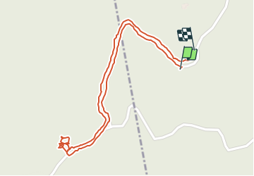

Length
1.4 km

Max alt
269 m

Uphill gradient
38 m
Km-Effort
2 km

Min alt
218 m

Downhill gradient
44 m
Boucle
Yes
Creation date :
2022-02-11 14:18:13.246
Updated on :
2022-02-11 16:31:27.226
2h12
Difficulty : Very easy

FREE GPS app for hiking
 SityTrail
IGN / Geographical institutes
SityTrail Plus
The world is yours!
About
Trail Walking of 1.4 km to be discovered at Occitania, Pyrénées-Orientales, Les Cluses. This trail is proposed by patbt.
Positioning
Country:
France
Region :
Occitania
Department/Province :
Pyrénées-Orientales
Municipality :
Les Cluses
Location:
Unknown
Start:(Dec)
Start:(UTM)
485938 ; 4703323 (31T) N.
Comments